We have developed a cloud-resolving numerical model which was named the Cloud Resolving Storm Simulator (CReSS). The dynamic process of CReSS is formulated based on the non-hydrostatic and compressible equation system with terrain-following coordinates. A map projection is available. Prognostic variables are three-dimensional velocity components, perturbations of pressure and potential temperature, subgrid-scale turbulent kinetic energy (TKE), and cloud physical variables. Physical processes are the subgrid-scale turbulence, the cloud microphysics of cold rain, surface process and ground temperature. CReSS has been developed for a numerical experiment of storms and clouds. On the other hand, it has a potential to be utilized for a high resolution prediction of an actual weather. Prediction experiments have been performed using CReSS. Two examples of prediction experiment will be presented: one is a typhoon and the other is a snowfall event.
For the prediction experiments, we established the system of a regional prediction experiment. The system receives output data of the Regional Spectral Model (RSM) from the Japan Meteorological Business Support Center every 12 hours. These data are interpolated and set for the grid system of CReSS automatically and used for initial and boundary data. The prediction experiments are performed using CReSS every 24 hours.
On 21 August 2001, the typhoon approached the Tokai district and caused an intense rainfall along the coast. The model domain was centered at the Tokai district and a 24 hour-experiment was performed with a grid size of 4 km. The typhoon was simulated to move into the calculation domain through the western boundary and to develop with spiral bands. Its movement and development were successfully simulated.
When a cold air outbreak occurs over the Sea of Japan, intense snow clouds develop over the sea and cause heavy snowfall along the coast of the Sea of Japan. This type of snowfall event occurred on 5 January 2003. CReSS simulated intense snowbands over the Sea of Japan. The result (Fig.2) shows an intense snowband along the Japan Sea Polar Airmass Convergence Zone with vortex street, snowbands of longitudinal mode on its south side and that of transversal mode on the north side.
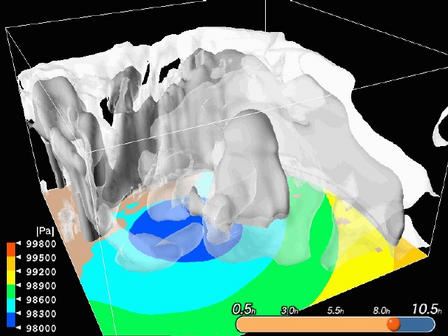
Fig. 1: Three-dimensional computer graphics of the simulated typhoon. The color scale indicates the surface pressure (Pa). The white regions are clouds and gray regions are precipitation. The indicator on the bottom right side is time from the initial in minutes. (The computer graphics were produced by Computer Technology Integrator CO.,LTD. )
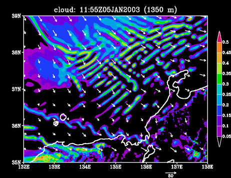
Fig. 2: Horizontal distribution of cloud water and cloud ice (g/kg) obtained by the simulation experiment of snow cloud over the Sea of Japan on 5 January 2003. The scale of gray levels is shown on the right hand side of the figure. The arrows are horizontal wind vectors.
The observational studies which targeted on the mesoscale precipitation systems in the Meiyu front were conducted around the Japan Islands and the Taiwan Island. These studies suggested that a moist air-flow from the ocean and a steep terrain are important factor of the local severe rainfall around the Meiyu or Baiu front. On the China Continent, however, there were few observational studies on the mesoscale precipitation systems in the Meiyu front until GAME(GEWEX Asian Monsoon Experiment/HUBEX (Huaihe River Basin Experiment) was conducted around the Huaihe River Basin in 1998. In this study, a structure of the precipitation systems and an interaction between the systems and their synoptic environment were investigated by using Doppler radar, objective analysis and satellite data. Furthermore, we conducted the numerical simulation to examine the heat and moisture fields around the system, which could not be determined by such observations.
The Meiyu front on the China Continent was usually located in the subtropical air mass (ISA type). However, the Meiyu front was located on the polar front (OPF type) when the polar air mass extends southward. In the ISA-type Meiyu front, it was clarified that the precipitation systems were located not only to the north of the convergence line near the surface but also to the south of the convergence line. For the formation and maintenance process of southern precipitation systems, it was important that moist and low-temperature air with low Lifting Condensation Level (LCL) advected to the south of the Meiyu front. On the other hand, the precipitation systems were located only to the north of the convergence line near the surface in the OPF-type Meiyu front. Moreover, a generation height of the precipitation in the OPF type was higher than that in the ISA type.
This study suggested that the difference of the precipitation systems between the ISA and OPF types was brought by the difference of LCL of the air parcel which advected to the south of the Meiyu front near the surface. This hypothesis was verified by the time-series of the temperature and humidity at the sounding site to the south of the Meiyu front. Moreover, This study clarified that the precipitation systems in the both types of the Meiyu front were maintained by the zonal cold pool with a length of 500--1000 km which was generated by their-self, and the concentration of the precipitation was occurred in the southern edge of the cold pool.
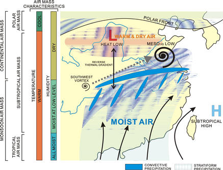
Fig. 3: Distributions of the precipitations system accompanied with the Meiyu front on the China Continent and the air masses around the front.
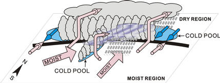
Fig. 4: Conceptual model of the precipitation systems associated with the Meiyu front in the subtropical air mass. The arrows indicate the air flow. The thick line indicates the convergence line which corresponds to the Meiyu front.
The Meiyu/Baiu front is a water cycle system which converts water vapor from the tropics and the subtropics to precipitation. Convective system which appears around the front is the main factor of the water cycle system. Its structure and maintenance processes have been clarified by observations in Japan and China in recent years. But they have not been understood comprehensively over the Meiyu/Baiu front extending for several thousand kilometers. It is known that a convective system produces a round shape, upper layer cloud area which has the diameter of several hundred kilometer and is called 'cloud cluster'. It is useful for the comprehensive understanding to investigate the behavior of cloud clusters using observational data of meteorological satellites.
Cloud clusters around the Meiyu/Baiu front appear especially frequently in the region around the eastern edge of China continent and East China Sea. 493 cloud clusters which appeared there in the five Meiyu/Baiu seasons in 1998 - 2002 were investigated by an algorithm developed proprietary. Then their characteristics unique to each domain (topography) were revealed.
Basically over land (Fig. 5, domain 1 and 2), appearance frequency has a diurnal variation with a peak in the afternoon and the variation is more remarkable in the mountainous domain of the Southeast Mountains than in the plain of Yangtze River Basin (Fig. 6, graph 1, 2). However, cloud clusters appeared frequently during both day and night in Yangtze River Basin in June where cloud amount was especially large. Characteristics of lifetime and size are different between the two domains. Those over the Southeast Mountains have the shortest lifetime and a moderate maximum area among the four domains. Those in Yangtze River Basin have respectively long lifetime and large maximum area among them (not shown).
In East China Sea (Fig. 5, domain 3 and 4), appearance characteristics are different between the northern part and the southern part (Fig. 6, graph 3, 4). Diurnal variation of appearance frequency with a peak in the early morning is remarkable in the norther part but it is not remarkable in the southern part. Cloud clusters in the northern part have the longest lifetime and the largest maximum area among the four domains. In the southern part, they are respectively short and small among them (not shown).
Finally, appearance characteristics of cloud clusters around the Meiyu/Baiu front were revealed.
This result will be one of the foundations for the comprehensive understanding of convective systems around the front. The processes can be understood comprehensively by utilizing these results together with results of case studies about convective systems.
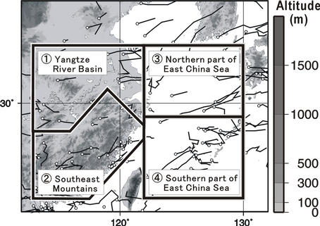
Fig. 5: Analysis domains divided by topography (closed with thick solid lines). The trajectories of cloud clusters which appeared in June and July, 2001 as examples are also shown. Open circle denotes the appearance location and the thin solid line extending from the circle denotes the trajectory.
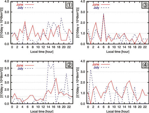
Fig. 6: Diurnal variation of appearance frequency of cloud clusters in each domain. The axis of ordinate denotes the number of appeared CCs in each local time (the axis of abscissa) per 106 km2 per 10 days.
In order to clarify maintenance mechanism of Mesoscale Convective System (MCS) in the humid subtropical region such as East Asia, it is necessary to investigate maintenance mechanism of convective cell within MCS. Three line-shaped MCSs, observed during heavy rainfall experiment in the downstream region of Yangtze River from June to July 2001, are selected as examples of MCS developing in the humid subtropical region. We investigate the relation between maintenance mechanism of convective cell and environment of three rainbands by dual Doppler radar analysis and Japan Meteorological Agency Regional objective ANALysis (RANAL).
As shown in Fig. 7, Dual Doppler radar analysis reveals that the three MCSs had following features. Three line-shaped MCSs are back-building rainband type with long-lived convective cells (BBL), back-building rainband type with short-lived convective cells (BBS), and broken rainband type with short-lived convective cells (BRS). By using RANAL, it is revealed that each three MCSs were formed in environments possessing different buoyancy, vertical wind shear, and vapor distribution. The humidity in the middle troposphere is especially focussed in this study. In a moist mid-level environment, long-lived convective cells were formed (BBL). On the contrary, in a dry mid-level environment, short-lived convective cells were formed (BBS, BRS). In BBL case, because evaporative cooling is not active due to moist mid-level air, evaporatively cooled outflow is weak. Therefore, low-level inflow can supply warm and moist air to convective cell continuously, and convective cell is maintained for long time. We clarify that humidity in the middle troposphere, as well as buoyancy and vertical wind shear, is important environmental parameter to determine the maintenance mechanism of convective cell in the humid subtropical region.
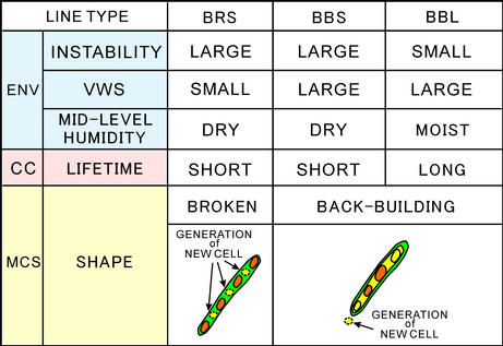
Fig. 7: Types of rainbands and lifetime of convective cell and environment with regard to three rainbands observed in the downstream of Yangtze River from June to July in 2001. ENV, CC and MCS indicates environment, convective cell and mesoscale convective system, respectively. VWS indicates vertical wind shear.
Water vapor is transported northward over eastern China and over the East China Sea and merges into the Meiyu/Baiu front. It was investigated in the past studies that water vapor is transported in the lower troposphere. However, there is no research for the difference of the horizontal transport and the source of water vapor between over eastern China and over the East China Sea. In this study, we examine them by utilizing the GAME reanalysis data.
Moist regions are distributed both over eastern China and the East China Sea in the southern region far from the Meiyu/Baiu front. The maximum value of total precipitable water is 60 mm both regions. The latent heat flux from the land surface over eastern China is 180 W/m2 (daily mean value) and is larger than that from the sea surface over the East China Sea (80 W/m2, daily mean value). On the other hand, the sensible heat flux from the land surface over eastern China is 60 W/m2 (daily mean value) and is also larger than that from the sea surface over the East China Sea (0 W/m2, daily mean value). The depth of moist layer over eastern China is 3000 m and is deeper than that over the East China Sea (less than 1500 m).
Now we summarize the difference of the horizontal transport and the source of water vapor between over eastern China and over the East China Sea as in Fig. 8. Over eastern China (Fig. 8a), atmospheric boundary layer is moisten by the supply of abundant latent heat flux from the surface (especially from the paddy fields). A convective mixing layer develops by the supply of moderate sensible heat flux. Shallow convective clouds develop around the top of this convective mixing layer and they transport water vapor from the atmospheric boundary layer to the middle troposphere. Consequently, deep moist layer is generated over eastern China. On the other hand, over the East China Sea (Fig. 8b), atmospheric boundary layer is also moisten by the supply of latent heat flux from the sea surface. But deep moist layer cannot be formed by the effect of no supply of sensible heat flux and the strong inversion layer by the Pacific subtropical high over the East China Sea.
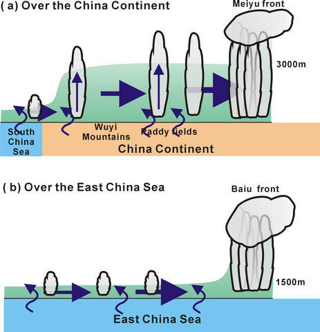
Fig. 8.: Schematic illustraion of the difference of horizontal transport of water vapor in the southern region far from the Meiyu/Baiu front over eastern China (a) and over the East China Sea (b).
In winter season, when low pressure systems develop over the eastern sea of Japan Island and the cold airmass outbreaks from the Eurasian Continent occur, a lot of snow clouds develop over the Sea of Japan. The snow clouds bring snowfall on the regions faced on the Sea of Japan. The snowfall patterns are classified into two types; mountain snowfall type and plain snowfall type. The real conditions and mechanisms of snow clouds inducing the plain snowfall type have not been clarified. We had a observation using the Doppler radar of Nagoya University at Oshimizu in Hokuriku from December, 2000 to February, 2001. The cold airmass outbreaks continued in the middle of January in the observation period. Two adjacent snowbands stayed along the coast in Hokuriku for about 20 hours from 15 to 16 and brought a large amount of snowfall on the coastal region. The data of the dual-polarization radar and the pictures of snow particles taken on the ground were mainly used except f or the Doppler radar. This study clarified the structure and maintenance mechanism of the two snowbands.
Figure 9 shows the schematic figure of the structure of the two snowbands. The north-westerly monsoon wind was weak and the land breeze with a thickness of 400 m developed. The convergence of monsoon wind and the land breeze made strong updraft. ``Snowband 1'' was formed in the updraft. The polarimetric radar data indicated that Snowband 1 was constituted of graupels. On the other hand, ``Snowband 2'' was formed in the weak updraft which the divergent flow of Snowband 1 produced in the middle layer. The all pictures of the snow particles taken below Snowband 2 were aggregates. The aggregates were constituted of two kinds of crystals the origin of which were different. One origin was Snowband 1 and another was in the weak updraft of Snowband 2.
This case study indicates the importance of land breeze as a mechanism concentrating snowfall on coastal regions. The analysis of cloud microphysics also shows the importance of microphysical process on the formation of relatively strong echo regions in the weak updraft such as Snowband 2.
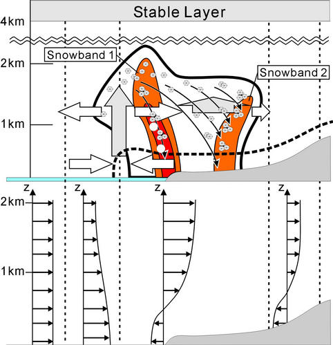
Fig. 9: The schematic figure of the structure of two stationary adjacent snowbands along the coast in Hokuriku from 15 to 16 January, 2001.